Volcanoes. For a geologist they are the driving reason to visit Hawai'i. Along with dinosaurs (paleontology), volcanoes are one of the specialized fields of study where my profession intersects with coolness. My 8-year-old son prepared for our visit by watching an episode of the
Magic School Bus, which raised me in his professional esteem. While my wife did most of the planning for our Hawai'i vacation, for Hawai'i Volcanoes National Park I possessively set the itinerary.
Our first stop was logically at the Kīlauea Visitor Center, about an hour's climbing drive (45 km) from Hilo. It's an important first stop where rangers convey current park conditions. It is also a good place to purchase a jacket or hooded sweatshirt. Cold-weather apparel isn't on the priority packing list for most vacationers in tropical paradise, but moist air rising from the sea can make even the moderate elevations around Kīlauea (4000 ft or 1220 m) bone-chillingly damp. The visitor center gift shop does brisk business in rain gear and warm clothes, at prices that would make an exclusive vendor of water in the desert blush.
After a brief orientation, we headed down Crater Rim Drive for one of the best views of Kīlauea Caldera, adjacent to the Jaggar Museum. Jaggar is named in honor of a famous geologist, which goes without saying. There are informative displays of the local geology, equipment used by volcanologists in the study of the volcano, and active seismographic equipment. And for anyone in the captive audience who missed the visitor center, there is an assortment of marked-up sweatshirts for purchase.
 |
| Massice Halema'uma'u crater is only a small portion of the caldera. |
But the volcano is the centerpiece, From Jaggar there is good access to paths along the open portions of the crater rim. The level crater rim trail leads eastward in about a mile (1.6 km) to vents on aptly-named Steaming Bluff that are hot enough to cook over. But first, as we were leaving the museum, a ranger introduced us to Pele's hair.
In geological terms, Pele's hair is simply volcanic glass threads formed when small blebs of molten lava are thrown into the air and spun out by the wind, freezing instantly into long hair-like strands. It wasn't immediately apparent until we were shown it, but once one knows what to look for, Pele's glistening hair is seen to coat everything within miles of Kīlauea Every tuft of grass is tangled with her resinous locks. For a goddess, she sheds a lot. Pele must be hormonal, which explains the frequent eruptions. Fortunately, none of the hairs we found found were short and curly.
 |
| Pele's hair. |
In places there are exhortations not to collect any lava souvenirs. I was instantly reminded of a guilt-inducing sign I once saw along an expansive bank of ash near Mt. St. Helens that pleaded, "What if everyone took a piece of pumice?" If everyone on earth took a hand-size piece of pumice from that immensity, the area would look exactly the same. Simple geometry isn't a strong suit of the Park Service anywhere apparently. Nonetheless, I kept a few strands of Pele's hair. If Hawai'i Volcanoes National Park wants them back, they can send a stamp.
We saw many signs of recent volcanic activity--steaming vents, vast hardened lava flows, Pele's ubiquitous hair, and (before we were ever in Hawai'i) plenty of glossy brochures featuring lava fountains--but if you're the typical rent-a-car tourist don't expect to stumble upon flowing molten lava. No doubt there are specialty tours outside the park and flyovers that offer the experience of "seeing red." The US National Park Service does not. It takes no little amount of money to visit Hawai'i, and one too many vacationing lawyers sniffing a lawsuit in the sulfur dioxide probably ruined it for the rest of us. Areas around erupting vents are closed to travel, and the ranger at Jaggar Museum almost gleefully conveyed that the promise of viewing an active eruption is largely a tourist trap. Hawai'i is one expensive trap.
 |
| The steam from these vents is hot enough to scald you instantly. |
 |
| The landscape above the caldera looks nothing like the first-time visitor's mental picture of Hawai'i. |
 |
| The crater rim trail east of Jaggar Museum offers good panoramic views of the caldera. |
But at dusk you can see a glow emanating from the Halema'uma'u crater of Kīlauea Caldera, if you park early enough at that same Jaggar Museum and can push through the crowds. The lava lake itself sits just out of sight beneath the rim, and ruddy spotlights on the crater walls would give a similar show, but we left after a long look, convinced we'd seen a spectacle of nature. Murphy's law is that there will be fountains of geysering lava the day after you leave. That nearly happened to my wife in 1983, although she was fortunate to see the eruption from her airplane window seat.
 |
| "Seeing red" was on my bucket list. |
I don't have quite the same obsession with the frozen variety of volcanic rock. Can it even be a self-respecting rock if it's less than a million years old? It appears nearly a third of the island has been resurfaced since I was born. I've begun to think it wasn't such a big deal when Kamehameha ruled the entire island. A good bit of it wasn't here in his day. There are vast potholes in the roads of Duluth, Minnesota older than the landscape of Volcanoes National Park. And the potholes kill way more people.
There is one hike where average visitors can fully immerse themselves in the vast magnificence of a mighty volcano. The Kīlauea Iki trail is a four mile (6.4 km) loop that took our family of five about 3 hours to leisurely navigate. From the Kīlauea Iki parking lot on Crater Rim Drive, hikers can head either direction from the trailhead through lush rainforest on the crater rim and switchbacking down to the desolate, still-steaming floor of Kīlauea Iki. Heading left will take you to the Thurston Lava Tube parking lot (an alternate trailhead) and then 400 feet (120 m) down to the floor. The difficulty level of the trail is moderate and suitable for children over toddler age, requiring no more than a modicum of fitness and good footwear. Respective signage at Thurston Lava Tube and the Kīlauea Iki lot each points towards the other as the trailhead without specifying the trail is in fact a loop, verifying there's at least one Newfoundlander in the National Park Service.
 |
| Kīlauea Iki crater, taken from roughly the area of the trailhead. The faint whitish line in the upper left quadrant is the trail, worn down by countless feet. |
Black volcanic rock that forms the crater floor is actually the surface of the lava lake that flooded Kīlauea Iki in 1959. The eruption sent fountains of lava soaring 1900 feet (580 m) above the floor of the crater and formed the cinder-and-spatter cone Pu‘u Pua‘i (gushing hill) to the height of 20 stories, so there was a lot of slumbering power beneath our feet. Massive gaping cracks in the crater floor formed as the lava lake cooled and contracted, giving the whole place the look of an overdone crème brûlée, now frozen in time just as it was after the last gasp of lava in December, 1959. Pele may be a goddess, but after a big eruption she behaves more like a male.
 |
| Pu‘u Pua‘i (gushing hill), a cinder-and-spatter cone formed during the eruption at Kīlauea Iki in 1959. |
 |
| The cave-like area to the right was the main vent. |
 |
| A geologist doesn't need the locks of Samson to do this... |
 |
| What comes down, must go up... |
 |
| Beginning the ascent from the crater. |
Before our big hike, it was worth taking some time for the short loop walk through Thurston Lava Tube and its surrounding rainforest. Lava tubes slowly form as a surface crust to highly-fluid lava flows, which vacate the tube when spent, leaving a worm-like subterranean trail. It's about 1/3rd mile (530 m) and takes about 15 minutes. The tube itself is in better condition than some subways.
After a long walk and a picnic lunch, it was the perfect time for a scenic drive while the kids dozed in the back seat of our rented minivan. Chain of Craters Road winds miles 19 miles (31.5 km) down to the sea from an elevation of about 3,700 ft. (1,128 meters), through a moonlike landscape of recent a'a and pahoehoe flows (1969-1974) sourced from a rift eruption of Mauna Ulu. Over much of the landscape, life still struggles to make a foothold more than 40 years later.
 |
| Desolate lave field below Mauna Ulu on Chain of Craters Road. |
 |
| The Chain of Craters drive is a good place to observe the difference between slowly-flowing a'a (blocky, viscous) and pahoehoe (ropy and fast-flowing) lava. |
 |
| Pahoehoe frozen in time. |
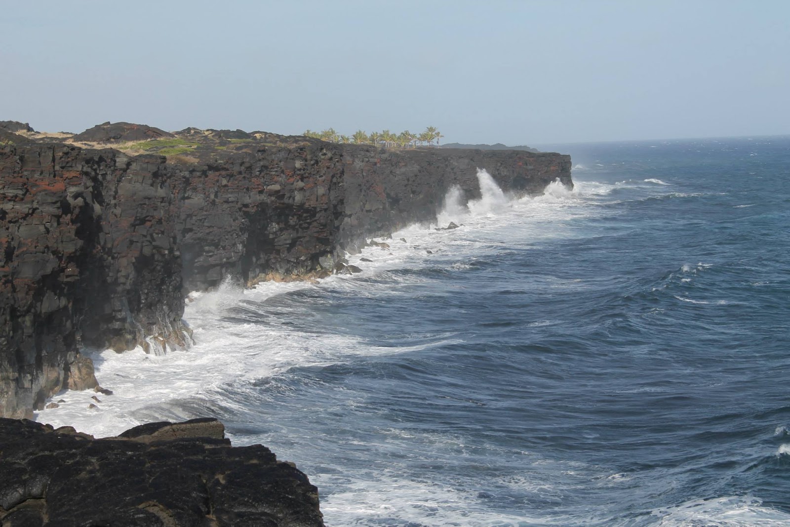
As it seems with all roads leading to the sea, the tsunami safety area is located still hundreds of feet in elevation above the ocean; Hawai'i is seems prepared for a global-scale, catastrophic asteroid impact, but the precaution is common sense in a state where a major earthquake in distant Alaska can inundate the shoreline with 30-foot waves. Chain of Craters Road currently terminates at picturesque Ho'lei Sea Arch. The road is closed further to the east, for now. The continuous eruption of Puʻu ʻŌʻō in the East Rift Zone since 1983 is now the longest in recorded history and has locally buried the road by up to 115 feet (35 meters) of lava. I silently cursed the lawyers under my breath for interfering with natural selection.
We watched rolling surf explode against the 90-foot-tall (27.4 m) sea arch for a long time, taking in the moment. For the next time we visit Hawai'i, the arch may no longer be there. Like the weather in Colorado, if you don't like the scenery in Hawai'i Volcanoes National Park, just wait 15 minutes. It is likely to change.
 |
| Sea cliffs at the (current) terminus of Chain of Craters Road. |
 |
| Ho'lei sea arch |